AuthaGraph and Geografia by Marumo Print
- Field:
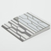
- Hi-tech Printing
- Location:
- Mitoyo, Kagawa
AuthaGraph and Geografia by Marumo Print
Products
-
 AuthaGraph ...¥7,980Approx: $47.56 USD
 -
 AuthaGraph ...¥8,480Approx: $50.54 USD
 -
 Set of Auth...¥12,480Approx: $74.38 USD
 -
 AuthaGraph ...¥21,260Approx: $126.71 USD
 -
![AuthaGraph World Map [PLATINUM]](/upload/save_image/11071624_5a015f9448d9f.jpg) AuthaGraph ...¥4,636Approx: $27.63 USD
AuthaGraph ...¥4,636Approx: $27.63 USD -
 Stand-Alone...¥3,663Approx: $21.83 USD
 -
![Stand-Alone World Map [mini-size]](/upload/save_image/10311643_59f829b78969f.jpg) Stand-Alone...¥2,852Approx: $17.00 USD
Stand-Alone...¥2,852Approx: $17.00 USD -
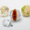
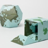
![Twistable GLOBE of Eight Cubes [EARTH & SKY]](/upload/save_image/05241331_519eed05f1d8e.jpg) Twistable G...¥4,961Approx: $29.57 USD
Twistable G...¥4,961Approx: $29.57 USD -
![Twistable GLOBE of Eight Cubes [EARTH&MOON]](/upload/save_image/11011208_59f93ab4cf9cc.jpg) Twistable G...¥5,285Approx: $31.50 USD
Twistable G...¥5,285Approx: $31.50 USD -
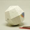
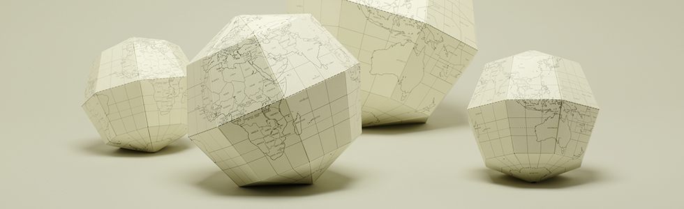
![Geodesic Globe with 80 Facets [PLATINUM]](/upload/save_image/05241135_519ed20c1bfac.jpg) Geodesic Gl...¥7,881Approx: $46.97 USD
Geodesic Gl...¥7,881Approx: $46.97 USD -
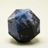
![Earth’s Axis, 23.4 Degree Sectional Globe [BLANK]](/upload/save_image/01231244_5c47e30f24d89.jpg) Earth’s Axi...¥4,312Approx: $25.70 USD
Earth’s Axi...¥4,312Approx: $25.70 USD -
![Earth's Axis, 23.4 Degree Sectional Globe [NIGHT]](/upload/save_image/05241318_519eea117fca3.jpg) Earth's Axi...¥7,232Approx: $43.10 USD
Earth's Axi...¥7,232Approx: $43.10 USD -
![The Phases Of The Moon, MOON GLOBE [BLANK]](/upload/save_image/11011253_59f9455466618.jpg) The Phases ...¥4,636Approx: $27.63 USD
The Phases ...¥4,636Approx: $27.63 USD -
![Earth's Axis, 23.4 Degree Sectional Globe [RAW MATERIALS]](/upload/save_image/05241323_519eeb4178bce.jpg) Earth's Axi...¥4,636Approx: $27.63 USD
Earth's Axi...¥4,636Approx: $27.63 USD -
![Pocket Earth: Foldable Globe [VOYAGE]](/upload/save_image/05241136_519ed23380cd8.jpg) Pocket Eart...¥4,961Approx: $29.57 USD
Pocket Eart...¥4,961Approx: $29.57 USD -
![[REALFAKE] SPECIAL Edition Origami - Panda Bear](/upload/save_image/05311748_592e8378200bf.jpg) [REALFAKE] ...¥4,474Approx: $26.66 USD
[REALFAKE] ...¥4,474Approx: $26.66 USD -
![[REALFAKE] TROPICAL series Origami](/upload/save_image/05311745_592e82abb6a70.jpg) [REALFAKE] ...¥4,474Approx: $26.66 USD
[REALFAKE] ...¥4,474Approx: $26.66 USD -
![[REALFAKE] SAVANNAH series Origami](/upload/save_image/05311739_592e814fe40c5.jpg) [REALFAKE] ...¥4,474Approx: $26.66 USD
[REALFAKE] ...¥4,474Approx: $26.66 USD -
![[REALFAKE] HOME series Origami](/upload/save_image/05311752_592e846b29c0e.jpg) [REALFAKE] ...¥4,474Approx: $26.66 USD
[REALFAKE] ...¥4,474Approx: $26.66 USD -
![[REALFAKE] POLAR series Origami](/upload/save_image/05311744_592e827b36e91.jpg) [REALFAKE] ...¥4,474Approx: $26.66 USD
[REALFAKE] ...¥4,474Approx: $26.66 USD -
![[REALFAKE] OCEAN series Origami](/upload/save_image/05311718_592e7c6f88f2e.jpg) [REALFAKE] ...¥4,474Approx: $26.66 USD
[REALFAKE] ...¥4,474Approx: $26.66 USD -
 Index Ring ...¥4,961Approx: $29.57 USD
Unique Printing Tech
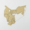
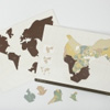
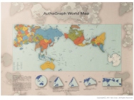
What is AuthaGraph and how different from legacy world maps?
Earth’s Axis, 23.4 Degree Sectional Globe
Hajime Narukawa : Inventor of AuthaGraph
Narukawa, born in 1971, took his first steps on the road to accurately redrawing the map of the world at the Shibaura Institute of Technology (Tokyo) in 1999, where his interest in geometry led to him studying the so-called geodesic dome structures developed by U.S. engineer, designer and inventor Buckminster Fuller (1895-1983).

Drill Design : Designers of Geografia
Founded in the year 2001 by Yusuke Hayashi and Yoko Yasunishi who both studied design in college, DRILL DESIGN is a studio where the pair give total project direction in various fields such as Product, Graphic, and Interior Design. The products they design, which are mainly everyday objects such as furniture, stationery, gardening tools, and kitchen utensils, are available for sale in many countries around the world, including the MoMA Store in New York. They have won numerous awards such as the Good Design Special Award.